| BeenThere-DoneThat | The Unofficial Guide to Great Britain | |
| Fort William | Highlands | Home |
| Fort William and the surrounding area | Location map |
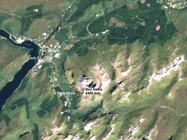 Image courtesy of BNSC Window on the UK 2000 |
This is a satellite image of the Fort William area.
Fort William, on the edge of Loch Eil, is seen on the left of the picture with part of the Caledonian Canal. Ben Nevis is near the centre of the picture with Glen Nevis starting near Fort Willaim to the West of and curving around to the South. The detail is better seen in the larger picture. |
||
| Fort William | Highlands | Home |
| Highlands | Scotland | |