Browsed by
Tag: Churches

England’s smallest and England’s oldest – Monday

England’s smallest and England’s oldest – Monday

"Just back from a short two night trip to the East Midlands."

'Oh – so that would have been pretty boring then'

"I knew you'd say that but you are quite wrong"

'What's interesting about the East Midlands then?'

"You really want to know?"

'Yes'

"Very well, you can't say you didn't ask"

Monday 2nd May 2011

We left home on a beautifully sunny morning and headed north. Our first destination was Oakham, the county town of England's smallest county – Rutland.

After leaving the A1 we went westward towards Oakham which would take us past Rutland Water. Rutland Water is an artificial lake, covering around 2.7 square miles, which provides a reserve supply of water in the driest and most densely populated quarter of the United Kingdom and is one of the largest artificial lakes in Europe with a 25 mile track around it for walking or cycling.

We travelled along the A606 on the northern side of the lake and the interesting thing is that although the road is at level higher than the lake it is not possible, generally, to see the lake because it is surrounded by wooded countryside.

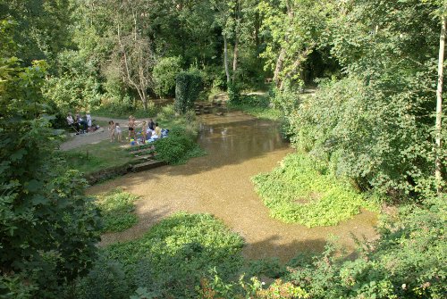
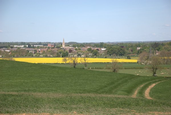
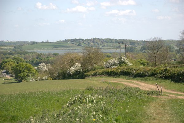
Around 2 hours after leaving home we parked near Oakham to have a quick walk up a nearby hill to see if we could get a view of the town and of part of Rutland Water.

This is the town:

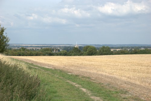
and this is part of the western end of Rutland Water:

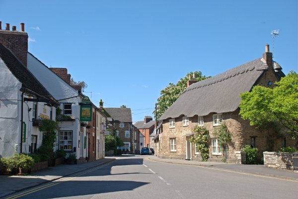
We then drove in to Oakham, parked the car (parking is free on Sundays and Bank Holidays and today is a bank holiday) and set off to look round the town. We were, at first, a bit disappointed because the town, generally, didn't look particularly attractive but then things started to get a little more interesting.

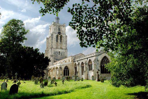
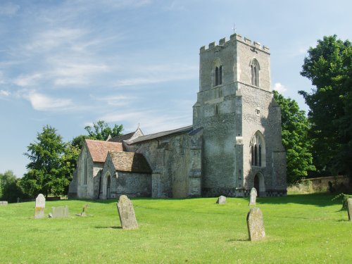
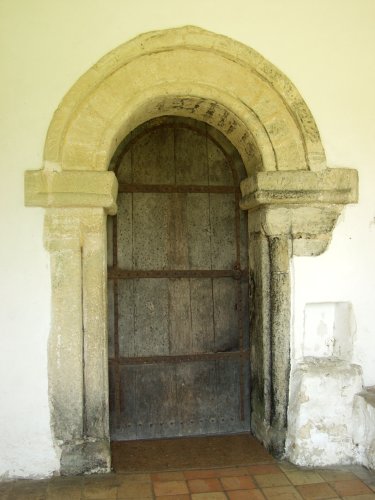
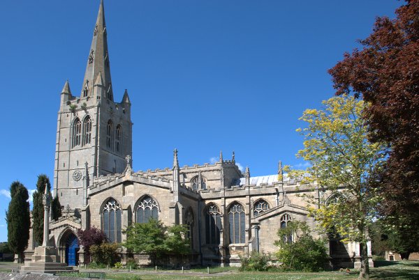
We walked up Church Street (We remembered seeing the spire soaring above the town in the distant view from the hill we climbed previously) and found All Saints Church quite easily (couldn't miss it really) at which point I spotted an interesting house in Northgate Street opposite.

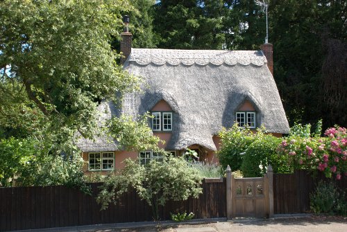
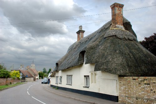
It had a nameplate on the wall with "The Manor House" on it but I have been unable to find any more information about it so I don't know what age it is but it is a pretty thatched house. We walked back to the church and followed the path alongside.

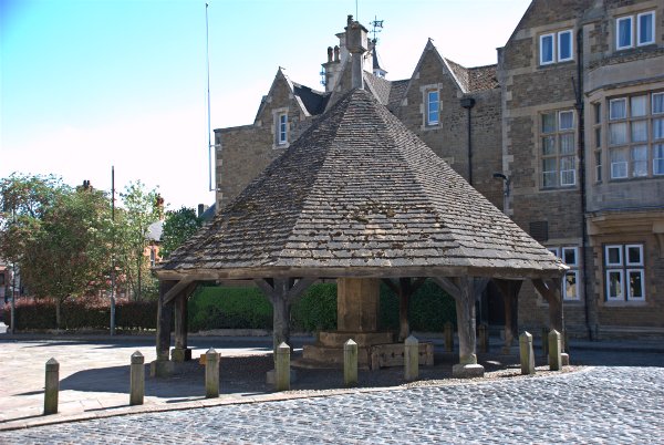
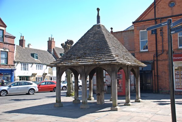
This led us into the area around the Market Place where we saw the Buttercross. In the shadow and on the right of the central pillar you may be able to make out the old stocks showing a row of holes for miscreant's legs.

A little further on and we saw the old town pump with an old style red telephone box behind and the Market Place beyond.

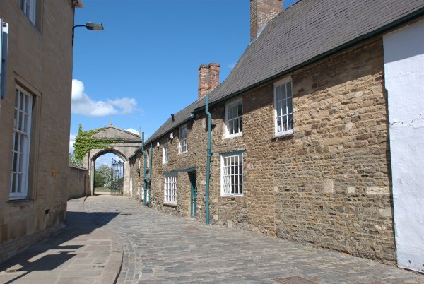
Leading off the Market Place was this little cobbled lane with a rather impressive gateway at the end.

A closer view of the gate shows a building beyond.

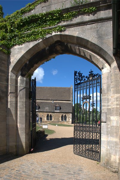
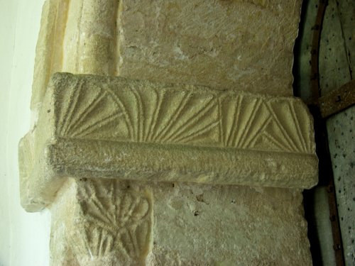
That is what is rather grandly called Oakham Castle. What you see is the only remaining part of what was originally a fortified manor house rather than a real castle. This was originally the Great Hall of the manor house and dates from 1180-90 and is the earliest hall of any English 'castle' to survive in such a complete state. We were sorry that it wasn't open when we were there as we would have like to have seen the inside.

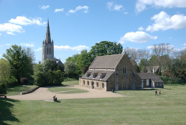
This shows the whole building and it's relation to the church.

We'd now seen most of Oakham's interesting features, it didn't take long, so we headed for our next destination and our first stop for the night. England's oldest next!


Living on the edge.

Living on the edge.

Yesterday, Thursday, started with a lovely clear sky and was forecast to stay that way until at least late afternoon so we decided to go and have a look on the western edge of Essex. This is supposed to be a thatched rooves area and it certainly seemed to be.

We started off in Widdington because it had a 14th century barn. Unfortunately it was open only on Saturdays and Sundays so we were not able to look inside – another day perhaps.

Priors Hall Barn, 124 feet long x 30 feet wide x 33ft high, is one of the finest surviving medieval barns in eastern England, dendro dated to the mid-15th century, with a breathtaking aisled interior and crown post roof, the product of some 400 oaks and little altered.

The view across the countryside from the barn was really quite nice.

Widdington is an attractive village with a good number of ancient buildings which did give us some thatched rooves and just how cute is this?

It looks just like a little face peering over the hedge and its hair is the same colour as mine. Then there was the beautifully made village sign and yet more thatch.

St. Mary's Church is a small traditional Essex church dating back to the early twelfth century.

Leaving Widdington we headed for Arkesden which is even further west and only a few miles from the Hertfordshire border – this could be bandit country we're heading into.

This turned out to be a really picturesque village with quite a lot of thatch.

We particularly liked this timber-framed cottage with brick infill.

There were a number of other villages that we passed through which were also attractive and there are others about which we've heard nice things so perhaps we'll have to go up that way again.
 

An imposter, tea for two but it’s all Greek to me.

An imposter, tea for two but it’s all Greek to me.

Yesterday, Thursday 17th June 2010, we went back to London. The reason we chose that day was because the weather forecast given the day before was for clear skies and sun all day. They were lying, of course, but more of that later. This trip turned out to be less satisfactory than previous trips for a number of reasons.

 
The first problem turned up soon enough when we had to change from our mainline train to the Central Line on the Undergound. There was a train waiting in the platform so we got on and sat down just in time to hear an announcement from the driver to say that the train wouldn't be going anywhere because of a signal failure further along the line. Luckily at this station we also had a choice of the Jubilee Line or the DLR. We were aiming for Piccadilly Circus so we took the Jubilee Line to Green Park and then one stop on the Piccadilly Line to Piccadilly Circus. We got there in the end.
 
We emerged into bright sunshine and I took a few more photographs of Eros. Eros is actually an imposter. Did you know that it isn't actually meant to be Eros but his twin brother Anteros?
 
To answer Tracey's query about the traffic – it is still not going around 'Eros' as it once used to but passes it by on one side.
 
 
We headed off down Haymarket to Trafalgar Square where we had a brief foray into the National Gallery to get a cup of coffee and to use their toilets. Back in to Trafalgar Square for a few more photographs then along the Strand.


 We noticed by this time that there was a substantial amount of cloud building up. There were some patches of blue sky but not many. This view of the Strand shows the church of St. Mary-le-Strand in the foreground and showing beyond is the spire of St. Clement Danes.

Nearby was the entrance gateway to Somerset House which used to hold public records such as birth certificates but now, in their own words, it is "An inspiring space for art, culture and creative exchange" whatever that is but it is a pretty impressive building.


At the end of the Strand near to where it changes to Fleet Street we passed the Royal Courts of Justice
 
 
and then we stopped to look at the George Inn which is nearly three hundred years old.
 
 
A little further on was Twinings tea shop which has been here since 1706 and was where Queen Anne and Christopher Wren used to buy their tea.
 
 
This building, in Fleet Street, survived the Great Fire of London and was built in 1625. It used to be the 'Wig and Pen Club' but is now, as you can see, a Thai Restaurant.
 
 
We were now back at a location we'd visited on our last trip, the Temple, and as there was now a lot of cloud about (so much for the weather forecast) which made trying to get sunlit photographs rather long winded we decided to have lunch. Surprisingly there are two cafes in the Temple grounds and we chose the 'St. Clements Cafe and bar'. They have a rather eclectic mixture of chairs and tables with the wooden tabletops left bare but the food is good. You can, in fine weather, have your meal in the garden if there is a vacant table (it's very popular).
 
After lunch we were hoping to see the interior of the 16th century Middle Temple Hall which is the building on the left in the top photograph below with the interior, hardly changed since it was built, in the lower photograph.


That is a seriously impressive double-hammerbeam roof and I won't patronise you by explaining that term as there are those of us who purport to know all things Tudor who will probably be forthcoming with that information (without cheating by looking it up on the Internet).
 
Middle Temple Hall is next to Middle Temple Lane which leads down to the Embankment. This is the impressive archway at the bottom of Middle Temple Lane looking into the lane from the Embankment.
 
 
Back out in Fleet Street we saw Ye Olde Cock Tavern. Apparently the narrowest building in Fleet Street, and looks it, as well as the oldest having been founded in the reign of Henry VIII.
 
 
We had found, prior to our trip, a book called 'One Man's London' which featured walks in London and which, in one section, described the area north of Fleet Street as a maze of little alleys, lanes and squares of the sort one might expect to find in Dickensian scenes. The book was written in the 1980s and we were very interested in exploring this area. We soon found one of the alleys mentioned, Red Lion Court, which led to the Red Lion Inn except that it didn't. There was no sign of the inn and after a while we realised that although the alleys and squares were still there the buildings had been demolished and replaced with ghastly modern office buildings .:bawl:
 
That was the biggest disappointment of the whole trip. We did, however, find a few remaining locations. One of the passages is Clifford's Inn Passage which leads to the gateway of Clifford's Inn, one of the oldest Inns of Chancery (1340) which has since been demolished although the gateway remains.
 
 
There was also Gough Square and Dr. Johnson's House nearby.


We made our way up to Holborn and emerged by Staples Inn which I photographed on a previous trip but at that time we forgot to have a look at the courtyard behind the facade. This time, however, we did look.
 
 
In appearance it is remarkeably like the other inns of court such as Lincoln's Inn and the Temple which shouldn't really come as a surprise. After leaving Staples Inn we made our way to the British Museum.
 
 
This was my second visit. My first visit was about sixty years ago. I can see this becoming a habit if I'm not careful. Amanda has been much more recently than I have and she didn't recognise this bit.
 
 
We decided it must have been changed relatively recently. A very pleasant space.
 
We were getting quite tired by this time but we wanted to see at least something of the exhibits and although we were feeling a bit droopy we didn't feel quite as bad as this chap looked.
 
 
I was that thin when I was 18 but probably not as good looking. If some parts of the image look a little odd it's probably reflections in the glass. I really needed a polarising filter for that but don't have one for the new camera.
 
We saw the Elgin Marbles in the Parthenon Gallery including Amanda's favourite – the one with the bull on it.


We also managed a bit of Egyptian/Assyrian stuff.
 
 
We managed to see only some of the Greek, Egyptian and Japanese galleries but eventually decided to stop, as we were so tired, and make our way back to the train and home. I took more pictures in the museum than I've shown here although the rest will probably appear on the main web site pages eventually.
 
That's the end of the current trip. If you stand around for a while another one may come along soon.
A round, another round and around.

A round, another round and around.

On our last trip to London we started where we had finished on the previous trip – St. Paul's Cathedral. On our previous visit we were there in the late afternoon which meant that the west end of the cathedral was nicely lit but the east end was in deep shadow but this trip it was the east end which was nicely lit by the morning sun.


On this side of the cathedral there were some nice gardens, nothing spectacular – but nice, and altough we could see the Stone Gallery round the dome there was nobody on it.
 
After we finished here we walked down Ludgate Hill (did you know that Ludgate Hill is the highest point in london?) and on into Fleet Street where we spotted these two buildings.
 
 
Known as 'Mary Queen of Scots House' they look a bit Tudory but we didn't really believe that, in view of the Great Fire of London, so we did a bit of digging – metaphorically you understand. It appears to be one building, erected by Sir John Tollemache Sinclair a scottish politician and landowner who was born in 1825 and died in 1912, so it can't be much older than 100 years. Appearences can be deceptive!
 
On the way along Ludgate Hill and Fleet Street I was trying to get a decent picture of the said streets but that turned out to be nearly impossible because of traffic getting in the way – especially buses. It then occurred to me that the best way to do that would be from the front seat on the top deck of one of those very buses. That is something I plan to try sometime but this time I did get a picture of one of the buses.
 
 
You may be able to see that there is a person in one of the seats on the top deck on the side nearest to the centre of the road and when I enlarged that section I could see that they had a camera in their hands. I'm not the only one with that idea then.
 
On our diversion to Lincoln's Inn we found this unusual sign.
 
 
So don't try and take any of the windows out without asking otherwise you could be in big trouble (no souvenirs please!).
 
Our second 'round' was the round nave of the Temple Church – a pretty amazing place.
 
 
It also had a pretty amazing Norman doorway which, having been built in the 12th century, is around 800-900 years old.
 
 
We saw this in Inner and Middle Temple –  a complex of gardens, courtyards, passageways and little lanes between Fleet Street and the Embankment. We discovered once we were home that we'd actually managed to miss half of it so we plan to go back and rectify that.
 
We emerged from the Temple onto the Embankment to our first view of the London Eye.
 
 
You can probably see that the Houses of Parliament are not very far away. Then a little further along I took this next picture of the Golden Jubilee Bridge – well half of it to be precise as it consists of two pedestrian walkways, one on each side of the railway bridge. We went up onto the bridge but didn't cross to the other side of the river. The bridge that you can't see, on the other side of the railway bridge, gives a good view of the London Eye.
 
 
Further along the Embankment we encountered Cleopatra's Needle together with the two sphinxes and two of the elephants that Marie mentioned of which only one is shown in the picture.


The sphinxes should have been installed so that they were facing outwards, guarding the needle, but someone blundered and they were installed facing the wrong way. Ooops!
 
We went from here to Westminster and eventually finished up at Trafalgar Square details of which are on the main web site in the London, Westminster pages.
 
We will, of course, be going back when we get the chance.
Springs and Things.

Springs and Things.

Recently a friend of ours who lives in Royston, Hertfordshire invited us over for the day and took us to the village of Ashwell which is six and a half miles west of Royston.

We parked by the roadside next to the Ashwell Springs -the “well” from which Ashwell gets its name.

The water rises from several holes in the natural chalk surrounding Ashwell village and the average flow is between 1,300,000 gallons a day to less than a million. It is at its highest level in March and April and lowest in September and October.

The water seen here is clear but very shallow and the brown colour is actually the gravel laying on the bottom. In this area we saw a number of places where water could be seen to welling up from beneath and these springs are one of the main sources of the River Cam which flows through Cambridge not far from here.

Ashwell is a picturesque little village with a 14th century medieval church which has a positively massive tower. Not only is the tower very tall but its sides are also extraordinarily broad.

Inside the tower at its base we saw some medieval graffiti which recounts the Black Death, a great storm in the late 14th century and a drawing of St. Paul’s Cathedral in London before the great fire. Some individual letters are not easy to decipher, being scored into the stone, and it’s all in Latin anyway.

There are plenty of ancient timber-framed buildings in the village of which the Rose and Crown is one.

This is where we had lunch, our friend having had previous experience of eating here, and it was exceptionally good and is to be thoroughly recommended if you are ever passing this way. I have to be honest and say that just writing about it makes my mouth water.

There are plenty of other ancient buildings including the Forresters Cottages shown below.

The central hall was built first in the 14th century, with two cross-wings (the jettied gables) added in the 15th century.  The left wing housed the pantry and buttery on the ground floor and sleeping accommodation on the first floor.  The right wing was a solar, having the best rooms for the head of the house.  To the right of it (at the far end of the photograph) is a 16th century extension.

This is another group of ancient timber-framed houses with the central colour-washed house showing some pargetting.

There is also thatch to be seen here – cottage? house? well yes but …

also a cob wall with a thatched top. Not all that common. The only other one we’ve seen was in Avebury in Wiltshire. There were also other thatched houses and cottages of which this is just one with that massive church tower showing in the distance.

We also walked from the village up to Arbury Banks, a Bronze Age Hill Fort, although there were almost no features to easily distinguish it from the surrounding countryside. It was, however, a very nice walk and worth it for the views from the top of the hill.

There’s that church tower again.

We had a very enjoyable and interesting day thanks to our friend.

The Chilterns: A beacon in an ancient landscape – Day 1

The Chilterns: A beacon in an ancient landscape – Day 1

The view from the top of Ivinghoe Beacon wasn’t as good as it could have been. We had just walked a short stretch of The Ridgeway, an ancient path that goes back to Avebury times, having arrived at our hotel just an hour previously after an uneventful drive of about an hour and a half.

But back to the view. It was a balmy spring day but there was quite a thick haze which prevented us seeing very far.

We had started from a car park down by the road from Aldbury and walked the one and a half miles to the top of the beacon.

This is where our walk started showing The Ridgeway stretching out in front and Amanda making her way along the path.

The Ridgeway starts from Avebury, Wiltshire and finishes on the top of Ivinghoe Beacon here in Buckinghamshire. The high ground on the left is the top of Ivinghoe Beacon.

Finally, with much puffing and blowing after a winter of sitting around and generally getting unfit, we arrive at the top. You can see how murky the view looked which was a pity as on a clear day it must be fantastic.

Amanda’s foot behaved much better than we thought it would and gave her no trouble at all. Looks promising.

After coming down from Ivinghoe Beacon we drove the very short distance to the village of Ivinghoe from which the beacon gets its name. First stop was Pitstone Windmill on the outskirts of the village and is the oldest windmill in the county

You should be able to see, to the left of the mill, the tower and spire of Ivinghoe Church and here is that same church close up.

We stopped, on the way back to our hotel, in Aldbury. An attractive little village sitting at the foot of the high ridge of which Ivinghoe Beacon is just a part in the area known as the Chilterns.

After that it was back to our hotel after our first half-day until tomorrow.

A Door into History

A Door into History

When we visited Saffron Walden in the north-west corner of Essex we also called in to a few ‘extra’ villages one of which was Hadstock. This is just a few miles north of Saffron Walden and very near the Cambridgeshire border. Hadstock is a picturesque little village although would not be considered as extra special.

Hadstock Village

Well – nothing extra special except for St. Botolph’s Church.

Hadstock Church

It does look, at first glance, like a fairly ordinary village chuch. Most of what you see was built by the Normans but it appears that they incorporated some parts of the previous church which was Saxon and dates from about 1020.

Church Door

This is the entrance door as seen from inside the church porch and both the stone archway and the door are Saxon. That makes this door the oldest door (around 1000 years old) still in use in Great Britain and has been there since it was first hung on its hinges by the Saxon builders.

Carving on Capital

On the picture above there is some interesting Saxon carved decoration on the doorway column’s Capital and just below it.

Inside there is further evidence of the Saxon church as seen in the next picture.

Column base

This is a cruciform church and these stone bases were probably intended to support a central tower which was never built and now helps to support part of the Norman structure.

It is suggested that this is King Canute’s ‘Mynster’ church which he had built in 1020 to commemorate victory over Edmond Ironside at Assandun.

An amazing piece of history for such a small village.