We have been to Hergest Croft Gardens, near Kington, a number of times but we had never been further up the lane to Hergest Ridge at the top. It was now time to change that.
We took our normal route to Hergest Croft Gardens but instead of turning into their car park we went straight past to the end of the lane where we parked and continued on foot through the gate along Offa’s Dyke Path.
Hergest Ridge straddles the English and Welsh border and is part of the Offa’s Dyke walk as well as a standalone highlight in any exploration of Herefordshire.
If you decide to start at the main carpark in Kington a modest climb of 1300 feet up from the quaint town will bring you to this point, where we started, and we continue through the gate on the Offa’s Dyke Route.
Heading for the top the views emerge all around and, as you walk, run, or cycle along the beautiful moorland, you may chance on wild ponies grazing , we didn’t see any, but we saw some wonderful views.
There were numerous people walking up here and you can probably see that Offa’s Dyke Path is well worn and, therefore, easy to see and follow.
There were plenty of wild flowers about and we saw this Tormentil and Gorse on the way up.
From the ridge you can look across to the Black Mountains and even as far as the Malvern Hills, with uninterrupted English and Welsh countryside landscapes all around.
Look out for the Victorian racecourse that sits atop Hergest and imagine the thrills and spills as the horses galloped around the track. As we approached the summit we could see the Monkey Puzzle Trees ahead. This area is part of the Hergest Estate and the trees were planted by one of the owners having seen similar trees growing on mountain tops in Chile in the early 1990’s.
You should also see the Whetstone near the summit, a natural stone, which in medieval times was used as a place to distribute food to people suffering from leprosy. Legend has it that the stone rolled down to Hindwell Brook each time it heard a cock crow. but it doesn’t attempt to explain how it managed to get back up the hill again.
Amanda giving an idea of the stone’s size.
The Whetstone and the Monkey Puzzle Trees.
On the way down we noticed this tree in blossom. Although the blossom is pink we think that it’s a Blackthorn.
This was an easy and very pleasant walk on a warm sunny day.
This trip took place on 30th March 2021 and this Blog Post is obviously late and there will probably a few more posts that will also be late.
Welsh travelling rules have recently been relaxed so it was time for a day out. We weren’t going far, just 16 miles to the high ground near Newtown and although the road is a typical narrow, winding Welsh backroad it didn’t take us long. We parked in the little free car park at the start of the Kerry Ridgeway which runs for about 15 miles to Bishops Castle although we weren’t going anywhere near the distance.
This is where we stopped and shows the Knighton-Newtown road with the little car park to the right and the start of the Kerry Ridgeway path along the side of the road. The Kerry Ridgeway is one of the oldest paths in Wales probably from the time of the Bronze Age.
We started up the path and soon reached the bend where the path turns away from the road and continues uphill.
As we had started from high ground we had good views almost instantly although it was very hazy.
We walked further along the path looking for the Cross Dyke and soon found it. We couldn’t really miss it could we?
The Cross Dyke, just beyond that wooden post, crosses our path and the next picture shows the twin banks heading downhill towards Newtown and the following picture shows them running down to cross our path and join the top picture of the two below.
The Cross Dyke marks an ancient boundary long since forgotten but, rather like Offa’s Dyke, they took a lot of trouble and effort to build it.
Nearby are the Two Tumps which are Bronze Age burial mounds. There is one on the left, just poking above the far horizon, and one to the right of that, and a little further back, with the far horizon just showing over the top.
We headed further up the path as far as this viewing point which has information, hill names etc., to identify what you can see around you.
It was now time to leave the Kerry Ridgeway, as we had more to do, so we headed back down the path admiring the views on the way.
Along the path I spotted a small area of tiny flowers and there is also a daisy to give a scale. Difficult to identify precisely because there are so many different varieties but it probably is a member of the Whitlow-grass group.
We soon arrived back at the car having been serenaded by Skylarks along the way. We drove towards Knighton for no more than a half-mile and parked in a large layby next to a landscape feature know as ‘The Ring’.
The Ring is a geographical feature caused by the River Teme eroding the bank and causing the higher ground to collapse and then the collapsed soil to be washed away. This picture was taken from road level on a previous occasion and the river is partly in flood producing this waterfall.
On this trip it was relatively dry with little water flowing.
This is the Ring itself. It’s called ‘The Ring’ because it is shaped like a large semi-circular amphitheatre.
We decided that we needed to climb down to look more closely at the waterfall which was at the bottom. It is not safe to climb down just anywhere because the sides are generally far too steep. So we had to visually plot a route down and then set off. The route we followed proved to be quite easy and it didn’t take us long to reach the river.
There was just a trickle of water over the waterfall, which is a pity, so we shall, perhaps, have to try again sometime when it is a bit wetter.
This is the River Teme, the same River Teme that flows through Knighton, heading off from the waterfall down the valley towards Knighton and we now hope to do the same. All we have to do is get back up to the road. We did that without incident, although slower than coming down.
A few years ago our friend Marie from the USA came over here and on one day we took her to Stokesay Castle near Craven Arms in Shropshire. We travelled by car and parked in the Stokesay Castle car park as that seemed to be the most obvious thing to do.
We recently decided to visit Stokesay Castle again but this time we were planning to park in the Shropshire Hills Discovery Centre on the outskirts of Craven Arms and walk to Stokesay Castle. Marie will probably recognise the views of Stokesay Castle. The Discovery Centre is on the edge of Onny Meadows; a large area of very nice water meadows with numerous footpaths.
We parked and then set off from the Discovery Centre to find the path that would take us across to the other side of the River Onny. We probably would have missed it if it wasn’t for the fact that I had my smartphone in my hand which showed us our position on a map. At the point at which it showed that we had reached the start of the path there was a rather insignificant gap in the hedge and that was the path we wanted. We probably wouldn’t have recognised it otherwise.
We were now heading for the river and on the way we passed some rather nice timber framed cottages.
Then we soon arrived at the ‘White Bridge’ over the river.
I stopped on the bridge to take a photograph of the river so there are no prizes for guessing whose shadow that is.
On the other side of the river we started to climb whilst travelling parallel to the river. The path went through some nice landscapes until it was fairly high above the river and then began to drop slowly until we reached river level again.
The River Onny here is quite deep and so flows very slowly. The overall impression is that of a pond rather than a river and there were plenty of dragonflies about.
As we walked alongside the river I spotted this Reed Canary-Grass which I thought looked rather nice. It is, unsurprisingly, a waterside grass.
Where the river was very shallow at the edges we saw a lot of fry, possibly Minnow, in large shoals. Each fish was only about one inch long.
It didn’t take us very long to get to Stokesay Castle which was looking its usual splendid self. This is an English Heritage property and all visits currently have to be pre-booked because of the Covid-19 situation but entry was quite straight forward. Needless to say there are plenty of features to look at and it really is interesting. They do have a nice gift shop at the entrance and we left carrying three jars of assorted fruit preserves and a bottle of liqueur. I don’t know how that happened.
Having had a good look around we decided that it was time to leave and started to walk back to the Discovery Centre. We passed this recently harvested field and I couldn’t resist a photograph partly because those large hills on the horizon are actually clouds.
We returned on a different path which passed through this wooded area of mainly Ash trees which looked very nice in their silvery bark.
Onward through the meadows were these Tansey flowers which I haven’t seen for some time and this is probably the largest bunch that I’ve seen.
As we approached the Discovery Centre we passed through these wooden representations of Mammoth tusks. These are here because there is, in the Discovery Centre, a full sized replica of Woolly Mammoth remains which were found near Condover, Shrewsbury.
The Discovery Centre is a modern building with a low profile and a grass roof.
The interior is very pleasant with a large gift shop and a well stocked cafe where we had lunch including, of course, finishing up with ice cream ( a very good selection of flavours). This is the passageway to the cafe.
That was the end of another interesting and enjoyable little trip.
Now that some of the Covid-19 restrictions in Wales have been relaxed we can go somewhere else – anywhere – so we did just that.
We headed 60 miles due west and found ourselves in Aberystwyth, Ceredigion. It took us about one hour and fortyfive minutes to do those 60 miles because most Welsh roads are anything but wide and straight. The last 10 miles was particularly wiggley but we got there.
We parked in a large car park on Park Avenue and were expecting to pay £1.70 for the day but all the pay machines were covered with large bags and there was no explanation so we ended up paying nothing.
We headed fo the sea front and soon after leaving the car park we walked past the Vale of Rheidol Railway Terminus which is a Heritage Steam Railway that runs to Devil’s Bridge. The last time we went to Devil’s Bridge we saw the other end of this line and took some photographs when a train arrived from Aberystwyth.
This time the terminus in Aberystwyth was closed with no signs of life anywhere so we continued past. Probably because of Covid-19. Pity really.
We headed for the harbour and were then planning to walk north along the sea front as far as the Funicular Railway at the far end of the bay. Where we parked was an obviously new area including a retail park but the buildings and streets suddenly changed when we reached the old part of the town.
This was one of the streets in the area of New Street and the hill in the distance could be Constitution Hill and the funicular railway runs up that.
It was a short walk further on to the harbour which includes the River Rheidol just before it runs into the sea. Both pictures are taken from the same viewpoint but in different directions.
A short walk from the harbour brought us to the sea front. This view is looking south and shows the wall at the entrance to the harbour.
Walking on South Marine Terrace along the sea front we passed these colourful houses and could see the castle in the distance.
Then an equally colourful plant bed.
A short way on we reached Aberystwyth Castle built by Edward I in 1289 but by 1343 the castle was in a bad state of repair. In 1649 Oliver Cromwell ordered the castle to be slighted, i.e. rendered unusable, hence its current condition.
We finally left the castle after having a really good look round and went back down to the sea front onto the New Promenade which was completed in the early 1900s.
On Constitution Hill in the distance, on the left of the next picture, there is a straight line visible running from the top to the bottom – this is the funicular railway of which more later.
In 1795 John Nash built the Old College buildings on the right, with George Jones as the architect, in Gothic style. It was later sold to the University of Wales who turned it into a college for higher education and it later became the University of Aberystwyth. It remained as the main part of the university until the 1960s when the university open a new campus near the National Library of Wales.
A short way on and we found two things – an ice cream kiosk and the pier. We had some ice cream, to help the local economy you understand, and had a look at the pier. It has to be said that this is the shortest seaside pier that we have ever seen. It does have amusements inside and a restaurant at the outer end which has a sun deck visible at the far end. We didn’t have time to visit the restaurant so we moved on.
When we reached this point along the sea front there was a turning off to the right which, having previously looked at the map, I knew led a short distance to the Tourist Information Centre. Having previous looked at some web sites which gave opening times I thought we’d pop in to see if there was anything we should visit that we might have missed. Needless to say it was closed with no signs of life. It was, however, a pleasant part of the town.
We went back to the seafront which has, as you can see, a rather fine beach. This beach runs all the way along the seafront promenade and has a greyish sand but sand nevertheless and there were plenty of people enjoying themselves.
We continued on towards the Funicular Railway passing some colourful, fine looking houses on the way.
We finally arrived at the bottom station of the funicular railway expecting it not to be running because of the current virus problems but it was so we decided to make use of it and take the easy way up.
We were asked to wear masks whilst on the ‘train’, which they supplied at a small charge, and the single fare was £7 for two.
We boarded the coach and, after a short time, it started to move. As with all funiculars there are two sets of rails and two coaches. When one coach is going up the other is coming down so that each coach acts as a counter-weight for the other.
This funicular is interesting in that the rails start up steeply then level off a little then go up an even steeper slope. When we reached the top I took a photograph from the station looking down.
You will be pleased to hear that there is a cafe at the top -we certainly were. They had a good selection of items on the menu including cake so we had to try some. We both had some cheesecake (very nice) and a cup of coffee each. The view from this level is really quite amazing.
The second picture was taken with a telephoto and is of the castle area with the war memorial on the right and parts of the castle showing on the left. You can also see the sundeck on the pier.
Once we had finished our cake and coffee we had to walk back down but just before we did that we had a look at the view north of Aberystwyth towards Clarach Bay. Beautiful.
This is the start of the footpath down but it isn’t that wide all the way.
We are almost at the bottom now.
On the way down we saw a number of wild flowers including Sea Campion, Thyme and Quaking Grass.
Finally back to sea level we now have to walk back to where we parked the car but we did pass through some more interesting parts of Aberystwyth.
We finally staggered back to the car and set off home but this time we are going home via the mountain road rather than the main road which brought us here.
We first go from Aberystwyth to Devil’s Bridge where we join the mountain road.
The next picture, which is just before we reach Rhayader, will be of particular interest to our friend Marie because she has been there. It shows one of the reservoirs in the Elan Valley and we brought Marie this way on that little road in the bottom right corner.
We reached home without incident although Amanda was feeling a little travel sick by this time. It took her about an hour to recover.
The weather is still fine, is forecast to be hot, and our new sense of freedom is still active so we decided on another trip. We went the half mile down to the railway station into England and set off on the Clun road. Clun is a small market town, in Shropshire, about 7 miles from us but the ancient river bridge, which carries this road over the river, is closed for a week to enable repairs to be made so we must cross the river by alternative means.
When we reach Clun we turn off the main road onto a narrow winding lane which brings us to this.
Yes it’s a ford. Who needs a bridge?
We carry on to the car park at Bury Ditches a few miles on and start our walk. We started this trip immediately after breakfast and as it was only a half-day trip we hoped to beat the heat. That turned out to be a dismal failure.
We are doing this walk in two parts.
We are first walking along a wide track which is more or less level to see if we can spot any Wood White butterflies. There are only a few colonies in Britain one of which is supposed to be in this area. I don’t know how far we walked but we did eventually spot a small butterfly we couldn’t identify. It was somewhere between the size of a Common Blue and a Small White but the colour appeared to be a very pale blue. There is no butterfly in this country that matches that description so was it a Wood White? It came from in front of us and went past so we turned and followed it. It was flying at about walking pace and the damn thing wouldn’t stop so that we could get a good look.
At this point we gave up and walked back to the car park and we still don’t know if we’ve seen a Wood White or not.
So now we started up the path which goes up to the Bury Ditches Hill Fort. It was getting hotter by the minute and the path had patches of sun and shade which meant that we could stop in the shade for a rest which we did frequently. The path has a moderately steep gradient all the way up, which didn’t help, and there were a number of wild flowers along the edges of which these are some.
St. John’s Wort
Hedge Woundwort
Meadow Vetchling
On the way up I took these two photographs from exactly the same viewpoint but you should be able to see that they appear to be quite different in appearance.
This is the HDR feature on my smartphone’s camera. HDR, if you don’t know, stands for High Density Range and it improves photographs like this significantly. Not long ago the only way to produce the HDR effect was to put the camera on a tripod and take 3 seperate photographs, one exposed for highlights, one exposed for mid-tones and one exposed for shadows which then had to be ‘blended’ in a post photograph operation using a computer. With many current smartphones that have that feature if HDR is set ‘on’ the phone’s camera will take 3 photographs almost instantaneously and automatically blend them. Simple!
Continuing our climb we eventually reached the top but the climb, in this heat, had been VERY UNCOMFORTABLE. This hill fort is very large and, from here, one can go up onto one of the banks to the left, straight on into the central area or off to the right up onto another of the banks. We took the easy way by going straight on.
We soon found that this is Foxglove Central. They were everywhere and the distant views were pretty impressive too.
Foxgloves as far as the eye can see – well almost.
This next view was from the top of one of the banks.
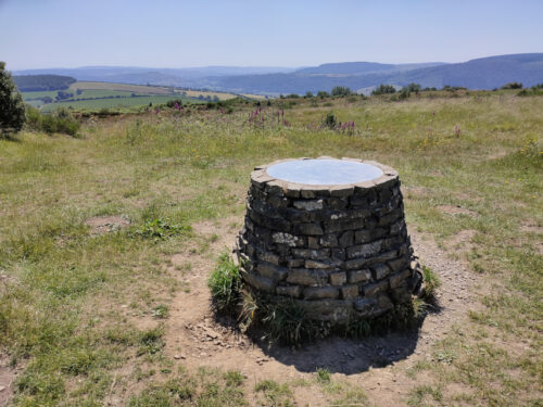
We finally reached this little structure. It’s not in the centre of the open internal area but it may be on the highest point as there is an engraved plate on the top which shows all the surrounding landscape features.
We felt by now that we’d had enough of the heat and so we headed back down to the car park. At least going down the path was a lot easier than climbing up and, having reached the car, we went home.
Let’s make this clear. We are not golfers and we do not play golf. This ‘Golf Ball’ is not really a golf ball and is somewhat larger than a golf ball.
Let’s start at the beginning. It was going to be a lovely day and, as we are in Wales, we should not travel more than about 3 miles under lockdown rules. However in England there are now no such travel restrictions so we drove a half mile to our station which is in England and were then free to travel as far as we like.
So we drove for about 45 minutes to Titterstone Clee Hill near Ludlow.
That is an impressive hill wouldn’t you say? We intend going to the very top but we are, of course, going to cheat.
Titterstone Clee Hill used to be quarried, although the quarries closed in the early twentieth century, and that means that there is an access road almost to the top. The view below is from the level of the car park looking back along the road the way that we came.
This is the car parking area looking towards one of the old quarry faces which is slowly being taken over by nature and doesn’t look anything like as raw as when it was a working quarry.
Time to start up to the top. We climb a moderately steep path and soon come across this view of another quarry face, again softened by nature, with two very strange devices looking rather like giant golf balls showing over the quarry edge.
These devices are radar domes. The largest is part of the National Air Traffic Services radar network and covers one of 30 overlapping regions of UK airspace. This one on Titterstone Clee monitors all aircraft within a 100-mile radius and the smaller of the two is a Meteorological Office weather radar which is part of a network of 16 radars across the country used to detect rain. I usually just put my hand out of the window.
As we climbed higher we passed these tiny flowers which turned out to be Thyme so it was nice to know that we had plenty of Thyme.
Continuing upward we reached a point where we could see one of the old quarries below us. This is the opposite view from the one I took from the car park looking into this old quarry. That fairly obvious light area on the left is the car park, with our car showing on the left, and just to right of centre those little dark blocks are the remains of some of the old quarry buildings.
The path that we are following is actually part of the Shropshire Way and the post in the picture below is a waymarker post for that path.
The shropshire Way long distance footpath covers some 200 miles crossing, as well as Titterstone Clee Hill, the Stiperstones and many other Shropshire towns and villages going as far north as Whitchurch.
We finally reached our furthest point which was the trigonometry point and Amanda tried to hide behind it without much success.
The hill in the distance, to the left of the trigonometry point, is Brown Clee Hill which is the highest hill in Shropshire and is a little higher than Titterstone Clee. The second picture is a closer view of Brown Clee.
This next picture shows the relationship of the trigonometry point and the radar domes.
The views from this height, about 1700 feet, are stupendous and not only that but they were accompanied by the sounds of Skylarks above us.
We started back down and passed these foxgloves on the way.
Have reached the car park we decided to have a look around the old derelict buidings. There was one on the left with two large cavities underneath and one, with legs, just above Amanda’s head. The building with the cavities underneath was used for loading railway trucks with quarried stone.
In one of the buildings there was some ‘Street Art’ (Graffiti). It certainly shows some artistic talent but I do wonder if any of the people that do this put it to good use. I have no idea what the symbolism means.
Finally we found something we had hoped to find – the Titterstone Incline. This was part of the narrow gauge (3 ft) railway used for transporting quarried stone which carried the stone from up here in the quarry downhill to the nearest road or railway.
All in all a very interesting trip. We had been here once before in 2005 when we stayed in Ludlow but we missed a lot of the interesting bits on Titterstone Clee Hill then. We have now rectified that.
It was nice and sunny this morning with the forecast that it would cloud up around lunchtime so we decided on a little walk before that happened. It was cool with a cold wind but still pleasant enough.
We left our house and went via the secret path (I’m not telling you where that is because it’s secret) onto Larkey Lane and thence to Ffrydd Road where we turned right, away from the town. After a short walk we turned up the little lane that goes up to Knighton Golf Course but only for a few yards when we turned right along a public footpath through Great Ffrydd Wood.
That’s when we encountered the rush. Wood Rush in fact. All that ‘grass’ in the picture below isn’t – it’s all Wood Rush.
In the next two pictures you can see the flower heads lit up in the sun.
We followed the current path to a point where it doubles back the way we came but traverses diagonally uphill. At this point we hopped over a stile into a field to try and photograph the Victorian Elan Aqueduct which used to carry carry water from the Elan Valley in Wales to Birmingham. The aqueduct, built in 1896, is difficult to see because of so many surrounding trees and in these next views one of the arches is visible plus part of the horizontal stone structure.
We then went back on to the path through Great Ffrydd Wood and continued uphill. It is a pleasant but long and winding path through the wood and eventually leads back onto the Knighton Golf Course road which, incedentally,is a private road but is also a public right of way.
We finally emerged onto open ground above Knighton. The far hill in the top picture is Kinsley Wood and the open ground on the very left is Panpunton Hill.
The next view, from the same viewpoint is of the Teme Valley running toward Ludlow. The red tree at the foot of the slope appears in both pictures.
Finally a rather nice view of St. Edwards Church, Knighton. This is a Victorian Gothic rebuilding of an earlier church of which the medieval west tower is the only surviving part.
That was the end point of our little walk so we went home.