Browsed by
Tag: Sheep

Squaring the circle

Squaring the circle

Another sunny day. Another dash for the car. Another zooming off to somewhere.

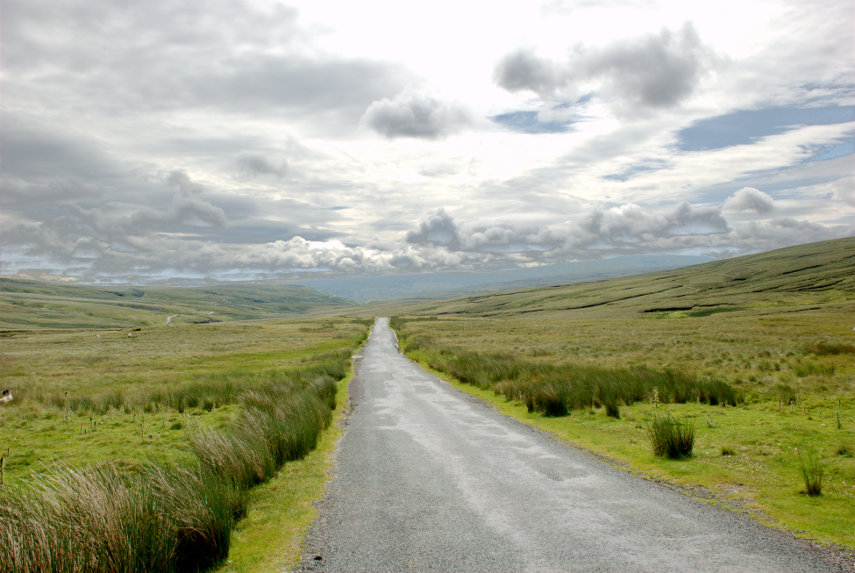
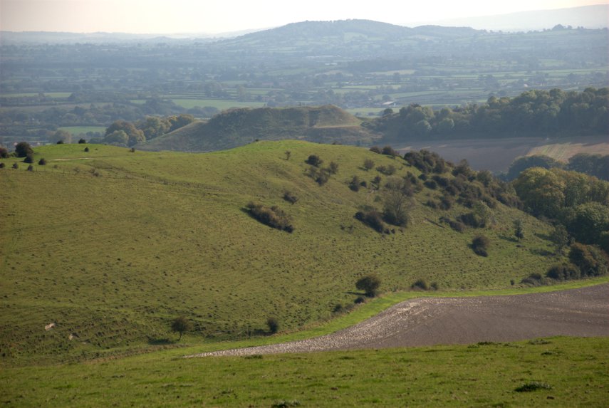
This time it was Radnor Forest which is 10 miles (or 20 minutes) from home. The nearest village is New Radnor and it’s called ‘New’ Radnor because it was new when it was built in Medieval times to replace Old Radnor.

We passed through New Radnor and travelled on the A44, heading south-west, for about 1.5 miles until we saw a car park signposted where we turned off. We followed the rather bumpy track for about 0.6 of a mile and parked the car.

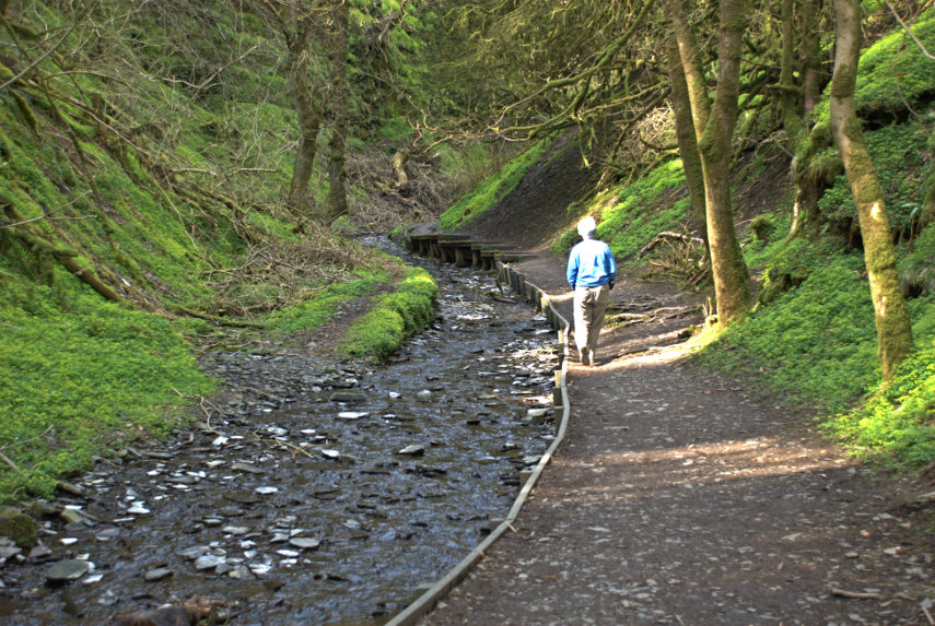
We walked along the track until we saw a path and stream going off to our left and followed it. Here is the intrepid Amanda following the stream.

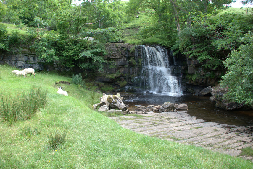
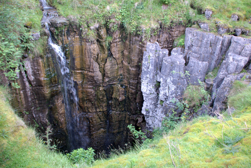
We are both keen to see what’s around that bend ahead and, when we got there, this is what we saw:


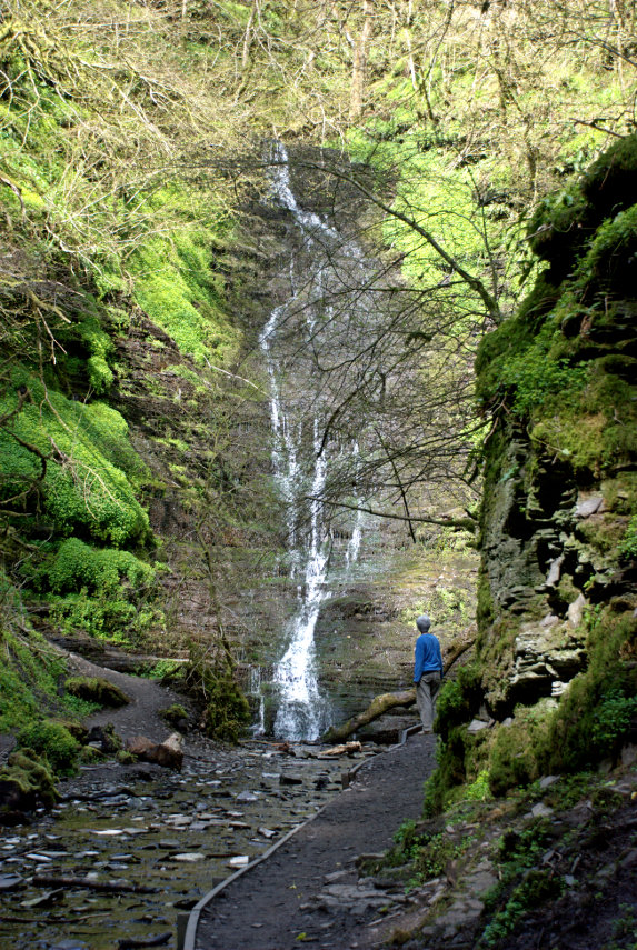
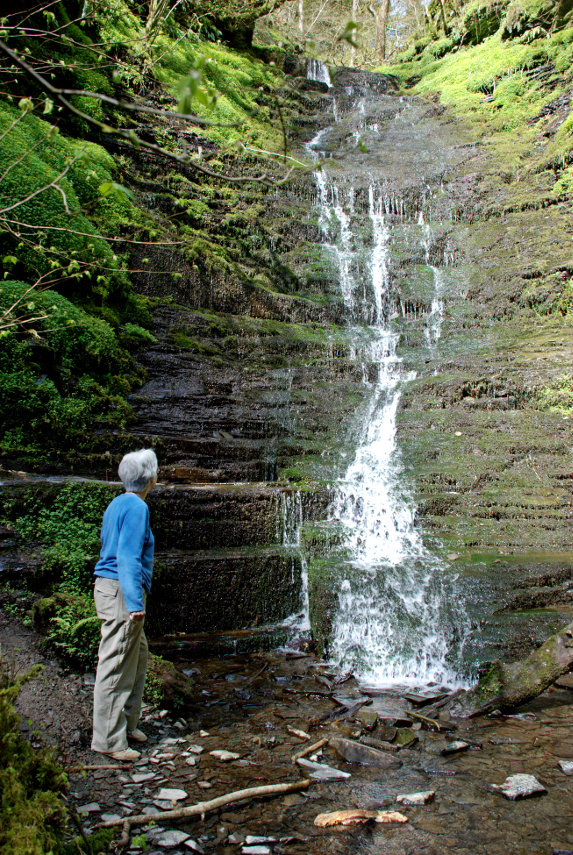
It wasn’t quite as high as we expected and it certainly wasn’t impressive but it is pretty. It is fairly dry at the moment and we can always pop back after some heavy rain when it should be carrying a lot more water. There is no way in other than the path that we used and there’s no other way out.

The path is easy to navigate and it has been supplemented with boarding in places where the bank would otherwise be too steep to walk on without falling into the stream and, to prove it, Amanda didn’t fall in.

When we arrived back at the junction we turned left instead of back towards the car and carried on. We soon found ourselves climbing a very steep slope. So steep that had it been a bit steeper it probably been a hands and knees job. We got to the point where we were wondering whether to turn back when we saw the top not too far up and decided to continue.

On the way up we met this chunky little chap.

That is a Dor beetle. They are not uncommon and are of a type of dung beetle which all have the rather unattractive habit of eating dung. I thought that you might like to know that. We left it to its business, so to speak, and finally made it to the top of the slope.

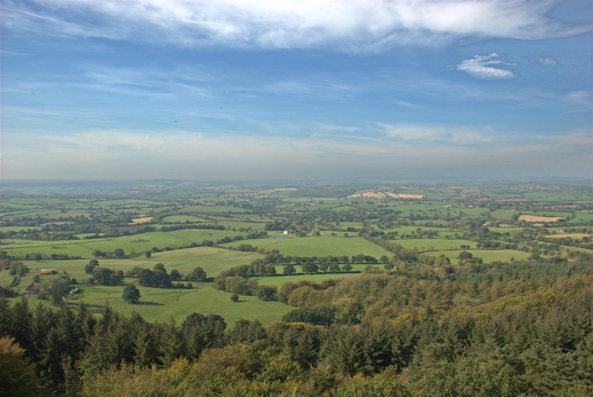
We were rewarded with this sight after we realised we were being watched.

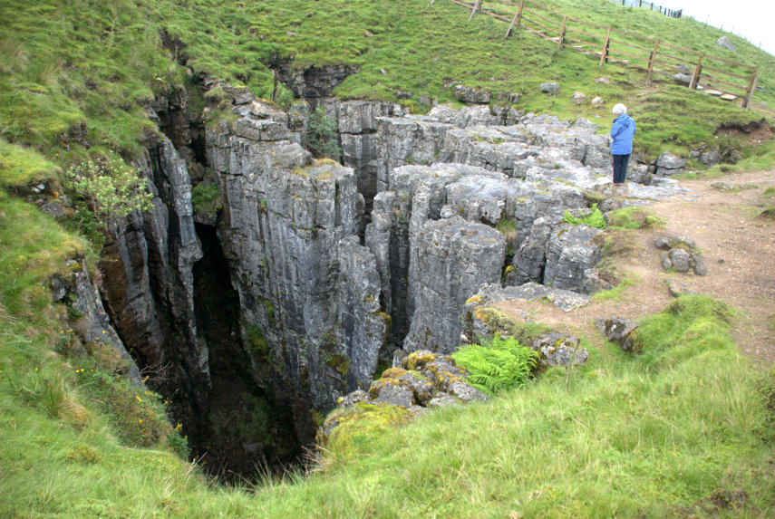
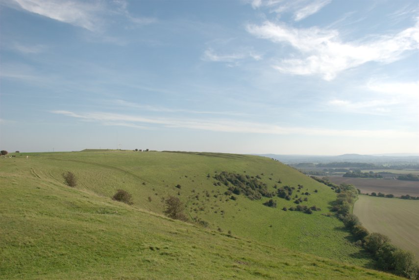
It was a Roe Deer. It watched us for a short time then trotted away. We joined another path and headed downhill. This time the slope was reasonable and at the bottom we were greeted with this view:

We rejoined the track and were soon back at the car.

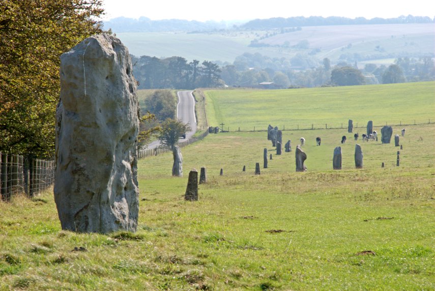
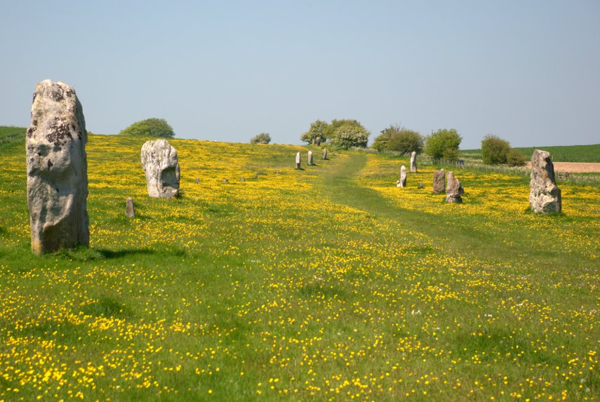
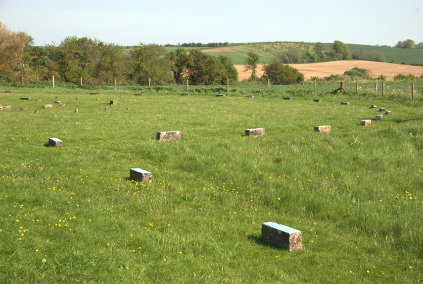
We hadn’t quite finished yet and although we were headed back home we were looking for something on the way. How would you like to see a stone circle? Well unfortunately for you there isn’t one but we might manage a stone square. A stone square?

What can I say? Apparently these groups of four stones are not uncommon hereabouts and they are more common in Scotland but nobody has any idea what they are for.

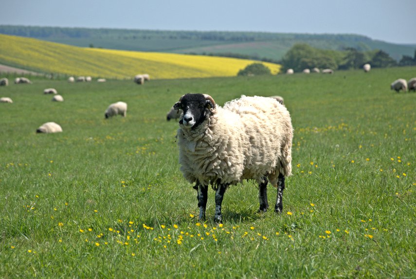
Amanda had also noticed, on the map, another item marked ‘standing stone’ which was on our route back so off we went. We found the right area and found a place to stop the car and get out. We looked over a nearby field but couldn’t see anything remotely like a standing stone. We moved to the gate of the next field which had a lot of sheep down the far end and spotted a small stone near the sheep. There was no public access in that field but there was a public footpath in the next field so I thought I’d walk along it to see if I could get a photograph.

Now this is where it gets embarrassing. I found a gap in the hedge which enabled me to get a clear view of the stone.

Then one of the sheep spotted me and started bleating which started some of the others bleating as well. That soon moved through the whole flock. I realised that they were all looking at me and going baaaa. Time to move, I thought, and headed back to the car. I was horrified to see them start to follow me. Remember that I’m not in the same field but in the next one and there is a stout hedge between us.

By the time I got to the car the sheep had reached the gate of the other field and we noticed that there were some small metal troughs on the ground with some of the sheep putting their noses in them. It suddenly dawned on us that they thought I was Mister Food and were waiting for the goodies. We didn’t have any, of course, and as we drove away we could see dozens of little faces watching us through the gate. I felt really mean.

We went home.

New place, First walk

New place, First walk

Today was a sunny day although the temperature this morning, early, was below freezing but we couldn't miss this chance to have our first walk since we moved in. We have, until now, done nothing but unpacking and settling in so this will make a change.

It wasn't far to the start of the walk, namely our front door and so we set off uphill. It was quite steep and we gained height quickly and I took my first photograph before we had even left the town. We were heading west to walk around Garth Hill and this view was of Knighton from the very western edge of Knighton.

Garth Hill is just over 1100 feet high but we weren't intending to go to the top but to go around it's flanks. The first part of the walk was along Glyndwr's Way which is well signposted and we were now heading north-west along the Teme Valley ( on our right) and on the other side of the valley is Panpunton Hill.

/

We soon entered the wooded part of the hill and, as you can see in the next photograph we were still climbing occasionally. This view is looking back along the path and the slope shown on the left is as steep as it looks. You wouldn't want to fall down there.

On the way through the wood we spotted some wild flowering currant which was rather pretty and colourful.

We were about halfway into the walk now and the sound of sheep bleating was quite common. There are a lot of sheep round here.

The total walk was only 3 miles and when we arrived at the 2 mile mark we saw this Blackthorn blossom and there was quite a lot of it. Very pretty.

A little further on we saw this little bracket fungus on a fallen tree.

Having walked full circle we finally joined the path that we had started out on and descended into the Cwm in Knighton – very near home now.

That was an enjoyable little walk and we were back in time for lunch.


Rock and Water – Day 5

Rock and Water – Day 5

After breakfast we are walking, not driving, out of the village. Weather is cloudy but dry. I do like scrambled egg with smoked salmon for breakfast – yum, yum!

We set off along one of the numerous footpaths around here heading north parallel with Scandal Beck (a beck in Yorkshire speak is a stream) intending to go as far as Smardale Viaduct and returning via the old disused railway track which has been converted into a footpath.

We hadn't gone very far when we saw this lovely group of Meadow Cranesbill (blue) and Meadowsweet (white) and a little further on there was a view of part of the village including the church tower.

We were walking uphill, not a particularly steep incline, and we could see some reddish brown cows on the brow. As we got higher and nearer we could see that there were also plenty of calves and we were going to have to disturb them because our route took us right through them. The cows and calves that were laying down stood up as we approached and moved to the side. We didn't want to come between a cow and its calf as the mothers can get a little uppity under those conditions and will sometimes charge.

Just as we were nearing the far side of the herd I noticed a very muscular beast staring at us and that was when I realised that it was a huge bull. It watched us for a while then lost interest. I couldn't help wondering which of us would be able to run the fastest.

Coming down the other side of the hill we had a good view of Smardale Bridge; a 17th century packhorse bridge.

Just beyond the bridge we reached a junction where various paths meet and turned east for a very short distance until we reached another path which continues along Scandal Beck towards Smardale Gill Viaduct (not to be confused with Smardale Viaduct).

We took that path and after a short time caught a view of Smardale Gill Viaduct.

As we made our way along the path above the beck we saw this butterfly; a fritilliary of some sort. As soon as I had taken a picture it flew away so I wouldn't like to say, with any certainty, precisely which species it was.

This is the path we've been walking on, in single file as it's not very wide, looking back the way we've come. You can see the old disused railway track over on the right.

The path has been climbing slowly for some time and we are nearly level with the top of the viaduct with the beck now a long way down.

We finally reach the old railway track and walk along the track towards Kirkby Stephen looking at the flora and fauna on the way. I managed to sneak up on this butterfly, a Common or Holly Blue, before I frightened it away.

We turned round and started back along the railway track, across the old viaduct and on towards Smardale Bridge. But before we left the railway track we saw a lot of orchids of which this is just one.

Then a final look back as we set off towards Ravenstonedale.

That was a nice day's walk. Tomorrow we go home.  :bawl: :bawl:
 

Rock and Water – Day 3

Rock and Water – Day 3

Today was our first full day in the area and we set off eastwards into the Yorkshire Dales towards Keld and Muker along the B6270 road. Don't take the 'B' classification as an indication that it is a reasonably fast road because this road is only one car wide, bends left and right and goes up and down all over the place. Luckily there are places where one can squeeze past other vehicles although we saw few of those (vehicles not passing places) but the scenery is really wonderfully dramatic.

Looking at the road in the picture above you will see that it disappears over a hump in the distance and then, if you look carefully, you can see the road re-appear over to the left about halfway between this section that we're on and the left edge of the picture. It really does wander all over the place. Ocasionally one can find an area big enough to pull off and stop which is what we did around Hollow Mill Cross by Tailbrigg Hill and look what we found – another limestone pavement.

One of the interesting features of this limestone area is that the soil is mostly acid which seems to be a contradiction on limestone but there is so much rain up here that all the calcareous content has been leached from the soil.

This pavement is very well weathered and you'll notice the little tarn (lake) in the distance which is only there because the acid soil is relatively impermeable and just to the right of that tarn is the tiny figure of Amanda who is just about to make an interesting discovery.

She is heading for that row of humps to the right of her figure and this is what she found.

It's what is known as a Shake Hole. These are often 60-80 feet deep or more and can be caused by the collapse of part of a cave system below, fracturing the limestone, and allowing water to seep down and dissolve the limestone to form these shafts.

We decided to move on and eventually came down off the high ground into a very small village called Keld. We found a place to park and walked down to the river where there were a couple of nice little waterfalls.

You may have noticed that on this trip the weather is rather changeable but it hasn't actually rained yet and we have had a little sun. We moved on to Thwaite where we had lunch and I now have a little tale to tell.

We had been to this area before, about 35 years ago, and on one night we stayed in a small pub in a small village and Amanda and I couldn't remember exactly where it was but she was keen to try and find out.

She remembered that it was called either The Queens Head or The Kings Head and we both remembered that it was run by an old lady. We both remembered that it was next to a small river which was thundering along because of all the rain at that time (nothing much changes does it?).

One of the people where we had lunch though, after hearing our tale, suggested that it may well have been in Gunnerside a few miles further along the road. So after lunch we set off and very soon caught a glimpse of Gunnerside.

Arriving in the village we soon found the Kings Head. This view of it is across the bridge over a small river. We went in and spoke to the people who now run it and had a brief look around and Amanda thinks that this could be the one. So one mystery solved.

Our next destination was the Buttertubs up on the Buttertubs Pass at around 1700 feet. Now that was an interesting road with a steep drop on one side and, again, rather narrow. There was a flimsy looking barrier along the edge which I remember wasn't there when we came this way before. They do seem to pander to motoring wimps these days.

We arrived at the Buttertubs and found space (there isn't much) to park. It was also raining and I was trying to take photographs and keep the camera dry. This is one of those Buttertubs.

Needless to say you wouldn't want to fall into one of those and here is Amanda doing her "let's look down a big deep hole but don't go too near the edge" thing by another of the Buttertubs.

Where does the name come from? It is said that the name of the potholes came from the times when farmers would rest there on their way to market. During hot weather they would lower the butter that they had produced into the potholes to keep it cool. I can't say I'm thoroughly convinced by that but I can't offer an alternative explanation.

We decided to call it a day at this point, having seen an awful lot of rock and water, and returned via that same hairy road to our hotel. More tomorrow.


Singing, singing, buttercups and daisies – Tuesday

Singing, singing, buttercups and daisies – Tuesday

We wasted a half-day today! It was, however, unavoidable. We left home at 9:30 AM and arrived at 12:30 PM after 3 hours of driving. That's the problem with travelling it has to be done to get anywhere but it could be better spent exploring.

The weather of late has been constantly cool, and raining for a lot of the time, but then last Monday, 21st May, good weather was suddenly forecast for at least 3 days so we booked some accommodation and left home on Tuesday, 22nd May for Wiltshire.

We had a clear run as far as the M25 and although there were no visible problems we started to see electronic signs displaying a message 'M4 junctions 6 to 10 long delays'. Guess what road we were planning to use for the next part of our route? We kept going past these signs and eventually decided that if we could see traffic queueing on the M4 slip road we would try an alternate route.

There was no queue on the slip road so we took a chance and went on to the M4 at junction 4. There were no signs of problems by the time we reached junction 6 and to cut a long story short by the time we passed junction 10 traffic was still flowing freely. There were no problems at all and I can understand why drivers tend to ignore such signs which seem not to be turned off once the problem has been cleared.

We arrived at Avebury under a clear blue sky with temperatures forecast to be around 75F. We didn't come for the stone circle but we did come partly for the stone West Kennett Avenue and partly to see inside Avebury Manor which has recently been restored. The restoration of Avebury Manor by the National Trust was the subject of a series of programmes on BBC television and it was very, very interesting so we were here to see for ourselves.

However, first things first! West Kennett Avenue starts from Avebury stone circle and winds across the landscape to the Sanctuary. It was originally lined with large stones of the sort which are to be seen in the stone circle but only some now remain.

This is a picture which I took on our previous visit in October 2011 which does not really show it to best effect.

So after lunch we walked along West Kennett Avenue to the lower end. This is what we saw this time.

Don't those buttercups make a difference? They show up the path along the Avenue very well apart from looking beautiful in their own right. There are also daisies in there somewhere but they aren't easy to see at a distance.

There is an old english folk song called "Strawberry Fair" of which the first two lines are:

As I was going to Strawberry Fair
Singing, singing, buttercups and daisies

Mid-June is probably strawberry time and buttercups and daisies are still in flower at that time but the first flush of Buttercups and Daisies appear towards the end of May.

Having reached the bottom of West Kennett Avenue we had also reached the path that went up and over Waden Hill to Silbury Hill so we just had to go to the top of Waden Hill to see the view of Silbury Hill.

We are just above the top of Silbury Hill at this height and looking a little left of Silbury Hill we could also see West Kennett Long Barrow which we have already featured on the web site. Even the standing stones which mark the entrance are visible at the left-hand end.

We went back down Waden Hill to the end of the Avenue and passed one of the locals looking a bit sheepish. Well you'd probably feel sheepish if you were seen wearing a thick wooly coat on a hot sunny day.

From here we went back to Avebury to look inside Avebury Manor. For the restoration it was decided to restore each room at a different time in the Manor's history, from the age of Queen Elizabeth I to the eve of World War II, and it is one of the few National Trust properties where visitors can touch, handle, sit in and lie on the furnishings.

This shows the Dining Room, with hand painted Chinese wallpaper, in the Georgian era.

The Victorian kitchen with one of the visitors, whose name shall remain anonymous but which starts with "A", leaning nonchalantly on the Dresser and she didn't even do the washing up.

This is a rather opulent bedroom, part of the Queen Anne Suite, and,yes, you could lay on it if you wanted although it would be nice if you took your shoes off first.

Then, of course, some of us have to start taking liberties on the Chaise Longue in the Withdrawal room.

We finally decided it was time to head for our hotel in Marlborough but, on the way, as we were passing the Sanctuary we were going to stop for a look.

This is where the Ridgeway starts and heads off to Ivinghoe Beacon in the Chilterns which I wrote about in the Blog – http://localhost/deoprrssw/?p=170

This is the signpost at the start of the Ridgeway, and it's a long walk to Ivinghoe Beacon,

and just across the road is the Sanctuary which was begun in about 3000 BC. The the site was constructed and modified in a number of phases, with eight rings in total (six wooden post rings and two stone circles) but, sadly, it is now just a set of concrete markers.

We went off to the Castle and Ball Hotel in Marlborough, where we were staying, for an evening meal and to prepare for our expedition tomorrow which features a lesser known historical monument and even more buttercups.
 

A Mere peregrination – Day 2

A Mere peregrination – Day 2

Saturday, 1st October 2011

After yesterday's walk we decided to have an easy morning looking round Mere. Our B&B is a very short distance from the High Street and the first thing we see is the 16th century George Inn which is the (apparently) timber-framed building in the foreground. I say 'apparently' because the George is actually stone built with a facing of timber and plaster. The stone building dates from 1580 but I don't know when the facing was added. King Charles II visited the inn in 1651 when he was fleeing after his defeat at the Battle of Worcester.

Beyond the George, on the opposite side of the road, is the Old Ship Inn with the large rounded archway. Originally built as a house in the 17th century it was reputedly converted into a coaching inn in 1785.

A short distance away is the Church of St. Michael the Archangel, dating from 1091, although little of that original church remains. A lot of the changes, including the tower and nave, were made in the 15th century.

That 15th century tower, as I mentioned yesterday, is massive. Someone in the 15th century had money to throw around.

The South Chapel had a rather nice stained-glass window which threw a coloured pattern on the lower wall and also put some blue spots on the brass of John Bettesthorne who was the benefactor of this chapel in the 14th century.

We left the church (there will be more interior photographs when we add Mere to the main web site) and made our way back to the Clock Tower by the George Inn.

We had a snack lunch then drove to Alfred's Tower which is part of the Stourhead Estate but has seperate access and its own car park.

This brick tower, also known as Stourton Tower, was built in 1772 on the north-western edge of the Stourhead Estate and is a folly: it is a building that arguably serves no purpose. It is 160 feet high with a spiral staircase of 205 steps which we duly climbed for the view from the top.

They didn't provide parachutes so we had to climb all the way down again. We then drove the short distance to the edge of Whitesheet Down, which we saw from Castle Hill yesterday, and promptly started climbing again. Will we never learn?

This is part way up, near the top, but we are aiming for that distant plateau because there is an Ordnance Survey Triangulation Point there and Amanda 'collects' them. There is also an Iron Age hill fort.

There are also sheep and people using hang-gliders. I don't think it's the sheep on the hang-gliders although it's difficult to see at this distance.

And there in the near distance, just poking up above  that spur, is Castle Hill again.

We eventually made our way down to our car and went back to Mere. The end of another interesting day.