Browsed by
Tag: Rivers

To England and back

To England and back

It's now early March and we haven't done any 'walking' this year yet. That doesn't include any usual walking like going to the shops and the walking about one does during normal activites. It was sunny this morning but it is forecast to rain heavily this afternoon so the time for a walk is now!

This is mainly for exercise and follows a 2 mile route we have already used for exercise and takes about 30 – 40 minutes. We leave home, head for the railway station where we cross both the river and the Welsh/English border, walk along below Panpunton Hill, turn left when we reach the Offa'sDyke path, cross the railway and the river arriving at this spot.

You should be able to see three things. The town in the distance, the rather mucky foreground and the cloud building up already. Continuing onward we soon arrive at a point just below the Offa's Dyke Centre.

The English/Welsh border is halfway across the footbridge and is shown by a yellow stripe with a yellow footprint either side (which you can see more easily in the larger picture)  for those people who may want to stand with one foot in England and one foot in Wales. I think that about half this walk is in England with the other half being in Wales. An international walk. cheeky

Back into Wales we go up from river level to the Offa's Dyke Centre, down into the town centre and then off to home. I think that's enough walking for this year so see you next year. devil

Houses, Water and Fungi

Houses, Water and Fungi

Houses.

We have lived in Knighton for eight months now and I have walked past this house on the main road through the town centre many times without noticing it at all. That may seem unbelievable but it is set back from the road in a narrow little courtyard so perhaps I might be excused. Even so it is the oldest house in Knighton dating back to the fourteenth century and I managed to miss it until now. sad

The facade was actually replaced in the 17th century but the house behind it is a Cruck-framed construction from the 14th century. I have no idea how large, or small, it is inside. I have now also added this to the the Knighton web pages.

Water

About a week ago we had some heavy rain. I mean HEAVY! It went on for a day or two and the stream which runs alongside our garden changed a little in that time. This it what it looks like under normal conditions.

After the rain stopped it was like this.

We are not in any danger of being flooded but it was moderately impressive all the same. It seems worse when you can hear the rushing water as well. The weather is a bit different now. Clear sky and sun this morning but one pays a penalty for that. Last nigh was the coldest that we have experienced since we've been here at, according to the weather forecast, 27F. Amanda looked at the Min/Max thermometer in her greenhouse and that read 20F. We don't want too much of that.

Fungi.

This is an 'Inkcap' fungus soon after it appeared above ground. So why 'Inkcap'?

After a few days it starts to open up from the bottom when you may see why it has that particular name.

A few days later it has progressed a bit more.

And then a bit more.

Until the final stage. Not a pretty sight.

Chains, Chapters and a Challenge

Chains, Chapters and a Challenge

In the week starting Monday 18th July we were going to have the builders in only on Monday and Friday and as the weather forecast for Tuesday was sunny all day we did the obvious – a day trip out.

We thought that Hereford would be a good place to go because it's only an hours drive away and we had never been there. We duly arrived in Hereford without incident and walked towards the city centre. The temperature was forecast to go up to 88 F, which is rare for this country, but at this time of the morning it wasn't uncomfortable (yet).

You may realise that Hereford has a cathedral and has the River Wye running throught it (through the city not the cathedral). There is a modern bridge across the river which takes most of the traffic but a short way away is the old bridge, just one vehicle wide, which can be seen from the new bridge.


The 12th century Norman cathedral is obvious beyond the bridge and the bridge itself is also 12th century.

By this time it was around mid-day and it was starting to feel hot. This is now the middle of July and it's the first day this year I have felt able to wear a short sleeved shirt. Having seen the cathedral from the bridge we now made our way to see the cathedral close up.


It was much cooler inside which was a great relief. The fact that this is a Norman cathedral becomes obvious when one sees the arches on either side of the nave.

The font is also Norman and does look rather worn but the base is of a later date.

There is also a crypt under the Chancel.


Entry to the cathedral is free but this cathedral does have some unique features for which  entry is chargeable but which we couldn't afford to miss. One of those features is the Chained Library.


This is how the library looked in the 1600s. The books are attached to their bookcase by a chain, which is sufficiently long to allow the books to be taken from their shelves and read, but they cannot be removed from the library itself. This would prevent theft of the library's books The practice was usual for reference libraries from the Middle Ages to approximately the 18th century. However, since the chaining process was also expensive, it was not used on all books. Only the more valuable books in a collection were chained.

One thing you may notice is that the books are the 'wrong' way round i.e. with the spines on the inner end. It was standard for chained libraries to have the chain fitted to the corner or cover of a book. This is because if the chain were to be placed on the spine the book would suffer greater wear from the stress of moving it on and off the shelf. Because of the location of the chain attached to the book (via a ringlet) the books are housed with their spine facing away from the reader with only the pages' fore-edges visible (that is, the 'wrong' way round to people accustomed to contemporary libraries). This is so that each book can be removed and opened without needing to be turned around, hence avoiding tangling its chain. To remove the book from the chain, the librarian would use a key.

The other unique feature at Hereford Cathedral is the Mappa Mundi (Map of the World).


Dating from 1300 it is the largest medieval map known still to exist. It represents the known world with Jerusalem being drawn at the centre of the circle, east is on top, showing the Garden of Eden in a circle at the edge of the world. Curiously, the labels for Africa and Europe are reversed, with Europe scribed in red and gold as 'Africa', and vice versa.

Great Britain is drawn at the north-western border (bottom left) and shown below enlarged. In the enlarged version Scotland is the island on the left with England to its right. Wales is shown as a separate island below England with Ireland shown as two islands below that.

Needless to say America and Australasia are not shown at all.

This is a reproduction showing the detail with more clarity.

We eventually decided we'd have to venture out of the cathedral to see more of the city and that's where the challenge is involved. The temperature must have reached its forecast maximum of 88 F because it was HOT! It was also very humid which didn't help at all and we found that we were walking in the shade at any and every opportunity. It is interesting to note that since 2001, extremes at Hereford have ranged from 92.5 F (33.6 C) during July 2006, to as low as 3.6 F ( -15.8 C ) during December 2010.

We walked away from the cathedral along Church Street going past The Grapes, a 16th century coaching inn, and into High Town.


High Town is the old market square and is now the main main shopping area in the city. It also features the Old House; a Jacobean (early 17th century) timber framed house which I must say is rather impressive. It is open to the public, entry is free, and it is worth a look inside.


That Hereford Bull is looking at me very suspiciously and, taking into account the look on its face, I don't think I shall hang around.

We were melting by this time and decided that if we could actually make it back to the car we would go home. We did and we did.
 

Squaring the circle

Squaring the circle

Another sunny day. Another dash for the car. Another zooming off to somewhere.

This time it was Radnor Forest which is 10 miles (or 20 minutes) from home. The nearest village is New Radnor and it’s called ‘New’ Radnor because it was new when it was built in Medieval times to replace Old Radnor.

We passed through New Radnor and travelled on the A44, heading south-west, for about 1.5 miles until we saw a car park signposted where we turned off. We followed the rather bumpy track for about 0.6 of a mile and parked the car.

We walked along the track until we saw a path and stream going off to our left and followed it. Here is the intrepid Amanda following the stream.

We are both keen to see what’s around that bend ahead and, when we got there, this is what we saw:


It wasn’t quite as high as we expected and it certainly wasn’t impressive but it is pretty. It is fairly dry at the moment and we can always pop back after some heavy rain when it should be carrying a lot more water. There is no way in other than the path that we used and there’s no other way out.

The path is easy to navigate and it has been supplemented with boarding in places where the bank would otherwise be too steep to walk on without falling into the stream and, to prove it, Amanda didn’t fall in.

When we arrived back at the junction we turned left instead of back towards the car and carried on. We soon found ourselves climbing a very steep slope. So steep that had it been a bit steeper it probably been a hands and knees job. We got to the point where we were wondering whether to turn back when we saw the top not too far up and decided to continue.

On the way up we met this chunky little chap.

That is a Dor beetle. They are not uncommon and are of a type of dung beetle which all have the rather unattractive habit of eating dung. I thought that you might like to know that. We left it to its business, so to speak, and finally made it to the top of the slope.

We were rewarded with this sight after we realised we were being watched.

It was a Roe Deer. It watched us for a short time then trotted away. We joined another path and headed downhill. This time the slope was reasonable and at the bottom we were greeted with this view:

We rejoined the track and were soon back at the car.

We hadn’t quite finished yet and although we were headed back home we were looking for something on the way. How would you like to see a stone circle? Well unfortunately for you there isn’t one but we might manage a stone square. A stone square?

What can I say? Apparently these groups of four stones are not uncommon hereabouts and they are more common in Scotland but nobody has any idea what they are for.

Amanda had also noticed, on the map, another item marked ‘standing stone’ which was on our route back so off we went. We found the right area and found a place to stop the car and get out. We looked over a nearby field but couldn’t see anything remotely like a standing stone. We moved to the gate of the next field which had a lot of sheep down the far end and spotted a small stone near the sheep. There was no public access in that field but there was a public footpath in the next field so I thought I’d walk along it to see if I could get a photograph.

Now this is where it gets embarrassing. I found a gap in the hedge which enabled me to get a clear view of the stone.

Then one of the sheep spotted me and started bleating which started some of the others bleating as well. That soon moved through the whole flock. I realised that they were all looking at me and going baaaa. Time to move, I thought, and headed back to the car. I was horrified to see them start to follow me. Remember that I’m not in the same field but in the next one and there is a stout hedge between us.

By the time I got to the car the sheep had reached the gate of the other field and we noticed that there were some small metal troughs on the ground with some of the sheep putting their noses in them. It suddenly dawned on us that they thought I was Mister Food and were waiting for the goodies. We didn’t have any, of course, and as we drove away we could see dozens of little faces watching us through the gate. I felt really mean.

We went home.

The quietest place under the sun

The quietest place under the sun

Clunton and Clunbury,
Clungunford and Clun,
Are the quietest places
Under the sun.

 (A. E. Houseman)

Of those four places, mentioned by A E Houseman in his poem, we visited Clun.

On our outward journey we didn't actually stop in Clun but drove straight through to Clunton where we turned north past Radnor Wood and Steppleknoll to Sunnyhill. We parked our car in a free car park provided by the Forestry Commission which was very handy otherwise we couldn't have stopped because the lane was so narrow (one car's width). We set off up the track where Sunnyhill didn't live up to its name – it started raining. smilies

Luckily the rain didn't last long and we started to see some sunny spells although the wind was still cold. After a short walk we arrived at Bury Ditches.

Bury Ditches is a British Iron Age Hill Fort dating from about 500 BC and one of the best preserved in the country. In the picture above Amanda is standing on one of the banks with a ditch to the left and another bank to the left of the ditch with another figure on the top. The main area enclosed by the defences is to the right.

You may notice that the views from up here are pretty spectacular.


This is how the fortified village would have looked when it was in use.

Having had a thorough look round we went back to the car and headed back to Clun.

Clun is a small, attractive market town in Shropshire just over 7 miles from us. This photograph shows the Market Hall and the square beyond.

The 2011 census recorded a population of 680 and research by the Campaign for the Protection of Rural England suggests that Clun is one of the most tranquil locations in England.

We arrived at lunchtime and liked the look of the Maltings Cafe next to the Sun Inn. So, based on that, we went in. It was a good decision. They had an amazing range of food for a small cafe and the food turned out to be excellent. We would recommend it without hesitation.

After lunch it was back to the hard work of looking round. We wandered along one of the narrow back streets looking at the old buildings and liked what we saw.

At the end of this lane we stumbled on the Hospital of the Holy and Undivided Trinity which is a well preserved example of courtyard-plan almshouses. This was founded in 1607 and in this case the term 'Hospital' is another name for 'Almshouses'. The pretty gardens and the chapel are open to the public but the inner courtyard is not. We had a look at the garden and the chapel.


A rather attractive and peaceful garden. Clun is not exactly a bustling metropolis and this is right on the outer edge of this quiet town so it was, well, very quiet.

Back towards the 'town centre' we started looking for the castle ruins. We knew Clun had a castle so all we had to do was find it. I remembered that it overlooked the river and we knew where the river was so we headed in that direction. We spotted some pinnacles of wall ruins and soon found the castle.

It has to be said that there isn't much of it left; the largest part being the remains of the Keep but up close that Keep looks fairly impressive. The whole thing was built on a grassy knoll high above the town and the surrounding countryside.


You can just see a small part of the river way below at the bottom of the top picture. All we have to do now is find our way down to that river and cross it. We walked across the top of the motte and were rewarded with this view.

That bridge is our way across so we scrambled down and it was pretty steep in places. There is the main road bridge, of course, but that route would have been slightly more circuitous. You can probably see the car park, which is free, and entry to the castle is free. However, having got down there, we walked towards the main bridge because I wanted to photograph it. It is an old packhorse bridge built in 1450.


It's not very wide as you can probably see (it was built for packhorses) but it is one vehicle's width so traffic can, and does, use it.

Our final destination was the church. The oldest part of the building appears to be the tower which was built around 1200 AD. The Nave is 12th century; the Chancel is actually 19th century.


That is a pretty impressive 14th century roof.

We were both feeling a bit tired by now so decided to call it a day and headed for home. The weather could have been better, but wasn't, and in any case it's only 7 miles from home so we can, and probably will, come back to Clun any time we like. smilies


An Offa we couldn’t refuse

An Offa we couldn’t refuse

My brother Paul is staying with us for a few days so it's time for yet another walk especially as it's sunny. We were going to look for some of the sections of Offa's Dyke around here.

Offa's Dyke is a bank and ditch built by Offa who was King of Mercia from 757 to 796 A.D. The dyke is thought to have been started in 785 AD and took a number of years to build. It runs from the South Wales coast for 177 miles to the North Wales coast following the English/Welsh border.

We knew that there was a visible section in the local park so we started there. You can see the profile of the bank, with the ditch on this side, quite easily.

We continued down the valley slope to the River Teme at the bottom where we saw this sign. The path, generally, is well marked by signs such as this.

The path runs along by the river through meadows often covered in sheep but not today. The hill beyond is where we are headed and Amanda is thinking 'Surely we're not going up there' and Paul is trying to ignore it completely. But, yes, we are going up there. A short way back we crossed from Powys, in Wales, into Shropshire, England where we will remain until we go back into Knighton.

We eventually reached the footbridge over the river. crossed the railway, and started up the slope. The first section is wooded but then we emerged on to open ground but one thing is constant – the steep slope. After much puffings and blowings we paused for a rest.

Amanda is enjoying the view, sitting on the path that we came up, with one corner of Knighton visible below. We certainly seemed to gain height rapidly but then we shouldn't be surprised;  I did say it was steep.

We did, eventually, reach the ridge where the path climbed more slowly. The views were amazing as this one of the valley shows. The little village and viaduct in the distance is Knucklas and it shows the meanders of the river very well.

We went as far as the next visible section of Offa's Dyke shown here with a fence running along the top of the bank with the ditch to its right.

Although there was some warmth in the sun the wind was icy and coming, so I understand, from the arctic. We decided not to hang around.

That is where we turned back and started our descent. One noticeable effect is that going down a steep hill is harder on the legs than going up although going up is harder on the lungs.

Yet another walk completed.


mTicket to Ride

mTicket to Ride

No, it isn't a typographic error it's meant to be 'mticket'.

I discovered something rather useful recently. It is that we can buy railway tickets on our railway line via a mobile phone and after paying for them they are then downloaded and stored on the mobile 'phone. These tickets can then be shown on the phone's screen to anyone who may need to see them. We then don't need to visit the ticket office or get tickets from a machine. So I decided to try it.

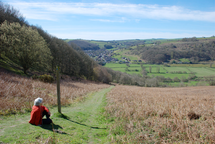
It has been a long time since we have been on any sort of trip which was because either the weather was bad or because domestic commitments got in the way. For example we have just had the outside of our house painted which was quite a long job but we now seem to be clear of domestic tasks so we were just waiting for a sunny day.

The weather forecasts don't help. A few days ago the weather forecast for Saturday was sunny all day. Then it changed to some sun and some sunny spells. Then it changed again to mainly sunny spells plus the chance of some showers in the afternoon. Then on Friday the forecast for Saturday was mostly sun so we took the chance.

We don't like generally travelling on a weekend because that's when everybody else does but this time the weather dictated when we travelled so on Friday I bought two mtickets and on Saturday 22nd August we caught a train to Norwich for the day.

It cost us less to travel to Norwich than it does to London even though Norwich is a bit further. We boarded a train at our one horse local station, where we have never had to show our tickets, and got off two stops later at Colchester where we caught the London to Norwich train. We were doing quite well until we were just south of Diss where the train slowed down and stopped. Signals I thought but then an announcement was made to the effect that there was a fault on the locomotive. It said that the driver was in contact with the service department and they were hoping to fix the fault within 15 minutes.

About 12 minutes later the train began to move – phew – and we eventually arrived in Norwich about 12 minutes late. I was expecting to show our mtickets on the train at some stage but, no, nobody wanted to see them. I did, however have to show them at the station barrier.

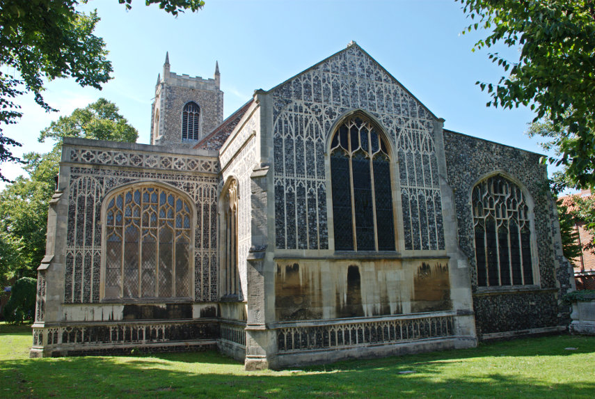
We caught a No. 26 bus in the station forecourt which took us to the Roman Catholic Cathedral. I bet you didn't know that Norwich has two cathedrals did you? This cathedral is no where near as old as the Anglican Cathedral, having been built in the late 1800s, but it is still a very impressive cathedral. When we were in Norwich last, 9 years ago, I did take one photograph of the outside but didn't have time to do any more.

This is another outside view that I took this time from the Cathedral Garden.

We went into their visitor centre, called the Narthex, where we encountered our first dragon. From 21st June until 5th September there are 184 dragons scattered around Norwich which they call an 'Art Sculpture trail'.

We were very kindly given a cathedral tour by one of the Deacons who retired a short while ago but who still obviously loves 'his' cathedral. It was a very interesting tour and we learned a lot that we would not have otherwise known about.

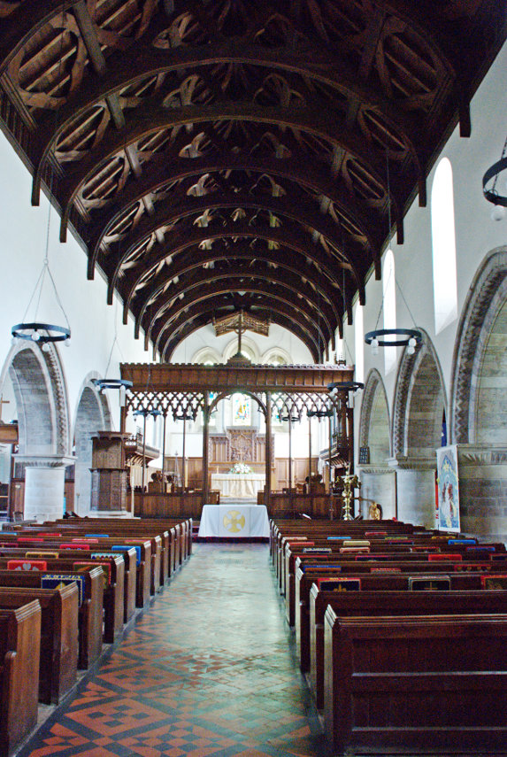
This shows the view along the Nave towards the East End.

There are lots of individual stone sculptures at the base of the pillars, at the top of the pillars and above them showing a great variety of forms and shapes. This is one on the base of a pillar.

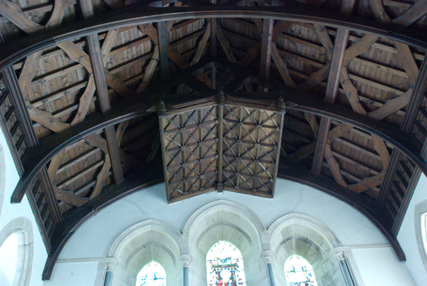
This next photograph was taken from the East End looking under the crossing and along the Nave and the one after shows the Crossing.


We finished up having a cup of tea/coffee and a sausage roll in the cathedral refectory and, I must say, their sausage rolls are particularly nice; cooked that day I was told. They do have other food here which I suspect is just as good so if you want a light lunch this is the place to go.

We left the cathedral and decided a quick visit to the Plantation Garden was in order. We photographed it thoroughly last time but the weather was decidedly better this trip and I took another couple of photographs.


If you look, in the second picture, just above the steps on the left you will see Amanda sitting behind the bench under the tree playing her part as an 'extra'.

We made our way back onto the streets of Norwich and headed for the river. In doing so we crossed Pottergate.

Norwich really does have some nice streets. We wound our way through numerous narrow back streets to the river bridge which took us north of the river; an area which we hadn't visited before. Our first point of interest was the 16th century Church of St. Michael Coslany at the junction of Oak Street and Colegate.

It was locked so we weren't able to go inside but it was yet another building with some fine flushwork.

We saw a number of churches which I won't picture or describe here but we finished at St. Georges back in Colegate where we found another dragon.

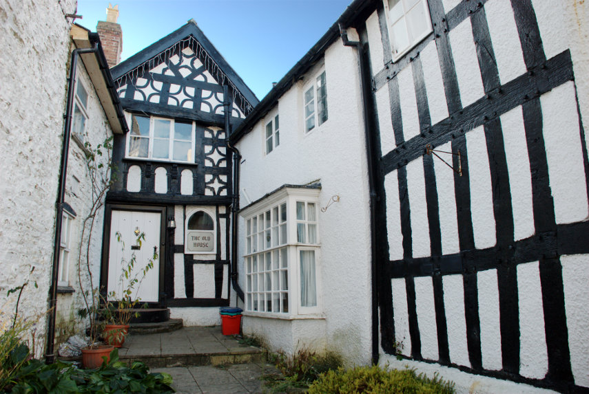
The view of the church from the eastern part of Colgate was rather nice together with that very attractive timber-framed building which was built by Henry Bacon who became sheriff of Norwich in 1548.


We continued along Colegate and turned right into Fye Bridge Street and along to the River Wensum. Over the bridge we found two more dragons.


We then turned left along Quay Side and thence onto the riverside walk. From there we went a short distance to the church of St. Martin at Palace Plain where I left Amanda to rest whilst I crossed back over the river and found yet another dragon.

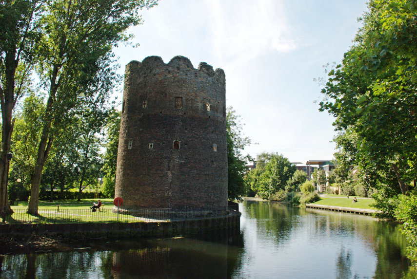
I walked along the north bank of the river on the riverside path to try and get a photograph of Cow Tower across the river. When we were last in Norwich I took some photographs of Cow Tower from the same side of the river as the tower and now I have it surrounded.

I walked back to the churchyard to find Amanda and there she was with a 'friend'. It was a Sparrow Hawk which had killed a pigeon and was eating it on the grass a short distance away. When I arrived it stopped eating and glared at me but didn't move away.

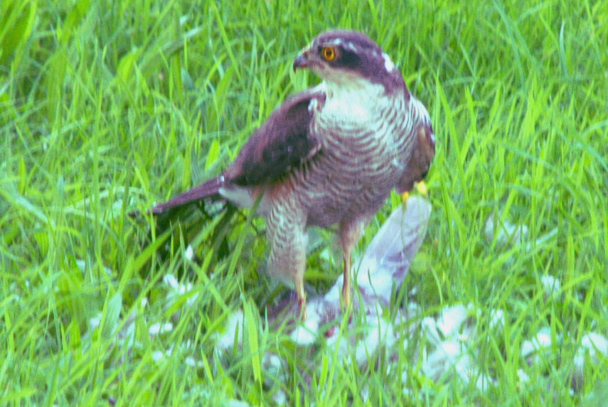
After watching it for a while we both moved slowly away and it remained, apparently, undisturbed. We headed back to Quay Side along to Wensum Street then right into Elm Hill. This is Elm Hill.

A well preserved medieval street. Looking in the opposite direction we can see the Britons Arms, the white building, where we are hoping to get afternoon tea.

Amanda had Darjeeling Tea, I had coffee and we both had Raspberry, Cream and Hazelnut Meringue Roulades which were the size of tea plates. On our last visit to Norwich we had lunch here and we both had their home-made pork pie. You just cannot get better anywhere.

After our late afternoon blowout we caught a bus nearby down to the railway station and caught the train home.

A good day.

P.S. Apparently the temperature around our tea time was in the low eighties – too hot. smilies